
Menu
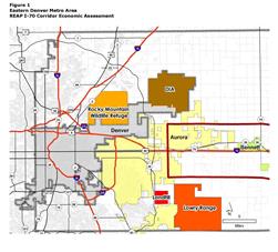 Economic & Planning Systems (EPS) was retained by Adams and Arapahoe Counties on behalf of the I-70 Regional Economic Advancement Partnership (REAP) to conduct an economic assessment of an eight-mile-wide corridor along I-70 from approximately E-470 to Deer Trail. The corridor represents the communities along I-70 on the eastern edge of the Denver Metro Area including portions of Aurora and the communities of Bennett, Byers, Deer Trail, Strasburg, and Watkins.
Pages/Documents
I-70 Corridor Economic Assessment
Arapahoe County Long Range Planning
REAP