

Posted on: December 10, 2018
The Adams County Information Technology & Innovation Department has developed a new Geographic Information System (GIS) website. Residents can view and download maps and data showing voting districts, building permits, code enforcement violations, floodplain areas, and more. Visit the site to engage with interactive maps or download static maps suitable for printing.
Posted on: April 17, 2024
Prevailing Wage for Public Project Policy Passed Unanimously by Adams County Board of Commissioners
The Adams County Board of Commissioners (BoCC) has taken a significant step toward ensuring fair compensation for individuals working on government construction projects by approving a new Prevailing Wage Policy. This policy mandates all Adams County government construction contracts valued at $250,000 or more must adhere to prevailing wage standards.
Posted on: April 11, 2024
Adams County Announces Concert Lineup for the 120th Anniversary of the Fair
Nate Smith, with special guest Kassi Ashton, will kick off the Adams County Fair with a concert on Wednesday, July 31, at 8 p.m., in the United Power Grandstand. This free concert is sponsored by Your Front Range Toyota Stores.
On Thursday, Aug. 1, ERNEST, with special guest Jon Langston, will perform on the United Power Grandstand at 8 p.m., following Professional Bull Riding (PBR) at 6 p.m. Thursday is also 4-H appreciation night, and $4 from each ticket sold will benefit Adams County 4-H. The evening is sponsored by Brannan Aggregates.
Posted on: April 11, 2024
Adams County Health Department Releases Landmark Study on State of Behavioral Health Services in County to be Used as Roadmap to Address Gaps in Services
Contact:
Nikki Kimbleton, Communications Director
M: 904.343.9627
E: [email protected]
Posted on: March 27, 2024
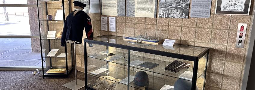
Adams County Partners with History Colorado to Develop Colorado Curated Story: USS Colorado
In 2023, when Adams County unveiled the Adams County Veterans Memorial – a replica of the USS Colorado – at Riverdale Regional Park, Adams County residents with ties to the renowned vessel donated items to honor the lives of veterans. Among the objects received by Adams County were letters, photographs, and artifacts that told the story of life aboard the USS Colorado.
Posted on: March 26, 2024
Colorado Air and Space Port Receives State Grant to Rehabilitate Ramp and Taxiway Areas
Colorado Air and Space Port (CASP) is receiving a $500,000 grant from the Colorado Department of Transportation (CDOT) Aeronautics Division to perform pavement rehabilitation work on some of CASP’s most heavily used taxiways and ramp areas. Adams County is providing $55,555 as the local grant match toward the work with a total project cost of $555,555 in a 90/10 partnership.
On Tuesday, March 26, the Adams County Board of Commissioners (BoCC) applauded the grant in Public Hearing.
Posted on: March 21, 2024
Colorado Board of Pharmacy Passes Adams County Health Department’s Proposal to Improve Access to Health and Pharmacy Services for Rural Residents and Other Medically Underserved Communities
The Colorado State Board of Pharmacy passed a regulatory proposal Adams County Health Department (ACHD) initially proposed that increases access to healthcare and pharmacy services in medically underserved and rural communities.

Posted on: March 7, 2024
Governor Polis Orders Flags to Half-Staff in Honor of Eagle County Paramedic Steve Zuckerman
COLORADO - Governor Polis ordered flags to half-staff on Sunday, March 10, 2024, from sunrise to sunset in honor of Steve Zuckerman, an Eagle County paramedic who passed away responding to a backcountry rescue call in Vail on Friday, February 23, 2024. Flags are being lowered in Zuckerman’s honor on the day of his memorial service.
Steve Zuckerman worked as ski patrol for Beaver Creek for over 25 years. He became a part-time paramedic in 2008, before becoming full-time in 2013.
Posted on: February 16, 2024
New Adams County Solid Waste Hauler Licensing Ordinance Aims to Increase Recycling and Improve Safety
Starting Feb. 17, residents and businesses in unincorporated Adams County can sign up for recycling services through their trash collection service provider when the county’s new Solid Waste Hauler Licensing Ordinance takes effect.
Posted on: February 15, 2024
Vote in the 2023 Employee of ALL Seasons Nomination Community Survey
Residents of Adams County are invited to participate in the voting process for the Adams County Employee of ALL Seasons award. The Employee of the Season recognition program recognizes the efforts of Adams County employees in all departments/offices.
In 2023, there were 26 employees who were Employee of the Season winners in the following seven recognition categories:
Posted on: February 8, 2024
Governor Polis Orders Flags to be Lowered to Honor Former Colorado State Senator Keith King
DENVER- Last week, Governor Polis ordered flags to be lowered to half-staff to honor former Colorado State Senator Keith King on the day of his memorial. The memorial has been scheduled for Wednesday, February 21 and flags are to be lowered that day from sunrise to sunset on all public buildings statewide.